~~~~~ Day 3 ~~~~~
Trekking Day 01
Travel Expenses
*** Total: 1,250 NPR ***
Transportation: 900 NPR
Food and Others: 300 NPR
Accomodation @ Ngadi (Seasons Lodge): 50 NPR
Kathmandu - Besisahar
Transport Information
Bus from Kathmandu to Dumre: 450 NPR (About 5 hours)
Bus from Dumre to Besisahar: 250 NPR (About 2 hours)
A stopover place enroute from Kathmandu to Dumre

Besisahar - Ngadi
Transport Information
Jeep from Besisahar to Bhulebhule: 200 NPR (About 1 hour)
Trekking Information
Trekking Time Today: 3/4 Hours
~ Bhulebhule (840m) - Ngadi (930m): 50 Minutes
Bumpy jeep ride from Besisahar to Bhulebhule

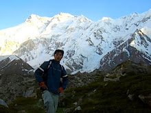
Finally starting my Annapurna Circuit trek!

Lots of long bridges like this built across rivers along the circuit

Trekking between farm lands and houses


And also alongside the green rice terraces

Local with her buffaloes

A small waterfall

A swing made with bamboo poles as support

International sport, soccer!

A local house with lots of corns hanging on the second floor

Sawing wood

Trekking route usually follows along a river and its valley

First stopver night at Ngadi

My guesthouse for the night with a wonderful host!
~ View Picture Enlarged ~

Simple guesthouse with a nice garden and outdoor dining area


Simple accomodation

Power cut are common, but a lamp will do =)

~~~~~ Day 4 ~~~~~
Trekking Day 02
Travel Expenses
*** Total: 950 NPR ***
Food and Others: 850 NPR
Accomodation @ Tal (Manaslu Guesthouse): 100 NPR
Ngadi - Tal
Trekking Information
Trekking Time Today: 7 3/4 Hours
~ Ngadi (930m) - Bahundanda (1310m): 80 Minutes
~ Bahundanda (1310m) - Syanje (1100m): 95 Minutes
~ Syanje (1100m) - Jagat (1300m): 90 Minutes
~ Jagat (1300m) - Chamje (1430m): 60 Minutes
~ Chamje (1430m) - Tal (1700m): 140 Minutes
Planning my trekking route over breakfast

First glimpse of the Annapurna's mountain, Ngadi Chuli (7871m) aka Peak 29 or Manaslu II

Great view!

Crossing a simple wooden bridge

A mule caravan

Another long metal bridge

Nice conical hill

Lots of corns!


Following the signboard towards Manang direction

Porter with a heavy load

Spectacular rice terraces carved out from hills


Valley of Marsyandi River

Nepali kids playing some sort of dice game

Some cheap and juicy oranges for a break!

A Gurung man with a traditional Nepali hat

Village of Jagat

Locals celebrating Tihar festival with a dance performance

Chamje village


Nice waterfall view from Chamje village

Crossing another metal bridge after Chamje

A multi level waterfall

Great view of the deep river valley

A board listing trekking time from one village to another
~ View Picture Enlarged ~

Gateway that marks the boundary between Lamjung and Manang district

Navigating along the river on a small path towards Tal

Can be quite a balancing challenge!

Finally reaching Tal, ending a real tiring day...

Safe drinking water stations can be found in various villages along the Annapurna Circuit to discourage trekkers from buying mineral water bottles which cause serious environmental problems
~ View Picture Enlarged ~

~~~~~ Day 5 ~~~~~
Trekking Day 03
Travel Expenses
*** Total: 950 NPR ***
Food and Others: 900 NPR
Accomodation @ Bhratang (Maya Guesthouse): 50 NPR
Tal - Bhratang
Trekking Information
Trekking Time Today: 8 1/4 Hours
~ Tal (1700m) - Karte (1850m): 85 Minutes
~ Karte (1850m) - Dharapani (1900m): 30 Minutes
~ Dharapani (1900m) - Bagarchap (2160m): 40 Minutes
~ Bagarchap (2160m) - Danagyu (2300m): 25 Minutes
~ Danagyu (2300m) - Temang (2500m): 80 Minutes
~ Temang (2500m) - Koto Qupar (2600m): 105 Minutes
~ Koto Qupar (2600m) - Chame (2670m): 30 Minutes
~ Chame (2670m) - Bhratang (2850m): 95 Minutes
Small garden of Manaslu Guesthouse in Tal

Walking thru the small village of Tal

A Tibetan Mani Wall

Large satellite dishes?

Long bridge leading to a path carved out from the cliff

A cute Nepali girl


Scenic river valley

Another waterfall

Sun rays slowing exposing the hills and valleys

Lots of rubbish!

Nice colorful flowers

Nepali at their daily chores


Information about Dona Lake (aka Manaslu Lake)
~ View Picture Enlarged ~

Horse riding

Arriving at Dharapani

First ACAP checkpoint stop at Dharapani

Tibet can be reached through in this direction, just 50km away across Larke La pass =)

A separate permit will be needed to go up to Larke La pass
~ View Picture Enlarged ~

Houses scattered along the river valley

Danagyu village

Another safe water station in Danagyu

A peek at the water treatment devices which include filtering and oxidation of water

Tibetan prayer wheels

Another glimpse of a mountain behind the clouds


Porters climbing up the steep slope

A small Tibetan stone stupa

Arriving at Koto Qupar from which side trek to Nar and Phu villages can be taken
~ View Picture Enlarged ~

Entrance to Chame guarded by a stone gateway, typical of a Tibetan village

Celebrating Yarthung Festival (long ago actually but the banner is still here lol...)

Locals dancing themselves away happily for the Tihar Festival

Water-powered prayer wheel

Safe water station in Chame

Walking through Chame

Locals gambling and celebrating

Tibetan prayer flags hanging over the bridge

Tibetan Mani Wall and prayer poles

Very unique stupa gateway

Colorful Tibetan paintings inside the stupa gateway


Tibetan scriptures carved onto rocks

Lots of mules!

Winding river

Porters taking a break from heavy loads

Riding on narrow path

Have to be careful crossing such landslide areas

Beautiful orchard garden with various fruits like apples

Finally making it to Bhratang after a long day trek

~~~~~ Day 6 ~~~~~
Trekking Day 04
Travel Expenses
*** Total: 1,200 NPR ***
Food and Others: 1000 NPR
Accomodation @ Braga (Buddha Hotel): 200 NPR
Bhratang - Braga/Manang
(via High Route)
Trekking Information
Trekking Time Today: 7 1/4 Hours
~ Bhratang (2850m) - Pisang (3200m): 130 Minutes
~ Pisang (3200m) - Ghyara (3670m): 105 Minutes
~ Ghyara (3670m) - Ngawal (3657m): 90 Minutes
~ Ngawal (3657m) - Munji (3482m): 90 Minutes
~ Munji (3482m) - Braga (3450m): 25 Minutes
Simple accomodation

My Tibetan host family

Walking through forest


Magnificient view of Paungda Danda, a granite cliff that looms like a gigantic wave high above

Peaks of Lamjung Himal (6983m)

And first view of Annapurna II (7937m)


Wide Manang valley and you can see Pisang Peak (6091m) in the distance

It was -2 degree celcius in the morning forest and even the mud floor was frozen

Arriving at Lower Pisang through its stone gateway

Finally the Annapurnas are in sight...Annapurna II at 7937m and Annapurna IV at 7525m

Nepali kids

Safe water station cum general store in Lower Pisang

Taking the upper route via Ghyaru and Ngawal to Manang

Information about the upper route
~ View Picture Enlarged ~

Crossing the bridges which lead towards Upper Pisang

Fantastic view of Annapurna II and IV enroute the high route

Small lake (Mring Tso) hidden away from the main trail


More Tibetan Mani Wall

View of Annapurna III (7555m) and Gangapurna (7455m) further down the Annapurna range


Almost reaching Ghyaru after a steep and long tiring climb up


Magnificient view of Annapura II and IV up here is definitely worth all the hard work!


Now you see me...

Now you dun! =p

Local at her daily chore

Ancient mediaeval village of Ghyaru with its flat-roofed stone buildings


Narrow walkway through stone houses

Tibetan Prayer Wheels

A Tibetan Chorten with Annapura III and Gangapurna

Lots of prayer poles on the roofs which produce a resounding sound under strong wind

Village of Ghyaru dwarved by the sheer scale of the Annapurnas

Pisang Peak rises high above Ghyaru village

Looking down at the valley where the lower route to Manang will be

Lamjung Himal range in the far distance

Closer and closer to Annapurna III and Gangapurna

You can see Ongre's airstrip at the bottom and Tilicho Peak on the right

Chulu West (6419m), Chulu East (6200m) and Chulu Far East (6060m) rises high behind Ngawal village

Another mediaeval village of Ngawal with its pastures

Tibetan Prayer Wheels with Annapurna III and Gangapurna

Bright white Tibetan script painted onto rock

Good view of Annapurna III and Gangapurna now

Little trees above the tree line

Sun setting behind Annapura III and Gangapurna

Nice rock formation

Fresh Seabuck Thorn juice is definitely a thirst-quencher


2 comments:
Just beautiful !!!
wow. whats a great picture. i like very much annapurna trekking picture
thanks for sharing. keep it up
best wish
Nepal trekking tour
Post a Comment